Sunday, April 29, 2012

Final Blog


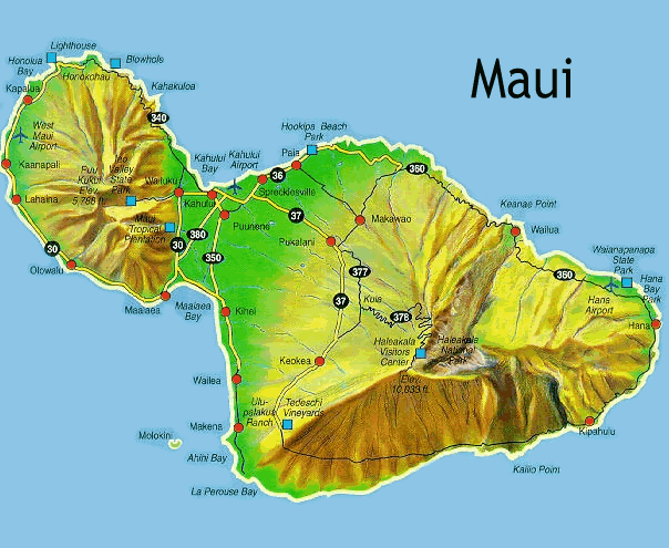
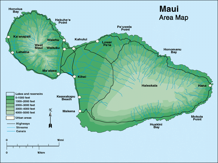
After living on Maui for over 18 years, I had no idea all of the cool physical geography it possessed, from its tropical weather and climate, to its many different soil types, and how Maui all started. To refresh your memory and mine, I will give a brief summary of the cool features Maui has. First of all, Maui was first created by two massive volcanoes which rose above a mile over the ocean's surface and created enough lava to fill the valley between the volcanoes. Maui is a "volcanic doublet", formed from the two volcanoes overlapping each other creating an isthmus to connect the two volcanoes. Maui's Haleakala Crater is the world's largest crater. Maui, created from volcanoes, Maui's main type of soil is Andisol which is volcanic ash soils. Volcanic Soils are formed from the volcanic ash and cinder deposits. While most of the world's volcanic soils are not highly weathered, there are exceptions on Maui. The beautiful features of Maui are due to the weathering and volcanism. 

7 Pools of Oheo Maui Hawaii
7 pools of Oheo Maui courtesy of http://www.citypictures.org/data/media/225/7_Pools_of_Oheo_Maui_Hawaii.jpg

Maui 10 years from now

Maui's physical geography shouldn't change too much. However, Maui's biogeography may change; the island of Maui's population will increase. They are building a ton of houses and cutting down Maui's natural environment and ruining its beauty. The one major thing that could happen in ten years is that Maui is an island surrounded with beaches so the beaches may erode some. As we learned in class, waves cut into the rock creating wave-cuts (Dr. Allen 2012). After time the wave will destroy the rock creating a cave. Here is an example of a before and after wave cut courtesy of Dr. Casey Allen 2012.
Before


After

Maui 100 years from now

Maui's physical geography after 100 years should see a more drastic change rather than just 10. The beaches that Maui has will no doubt be eroded a lot more. Waves, generated by storms, wind, or fast moving motor craft, cause coastal erosion, which may take the form of long-term losses of sediment and rocks, or merely the temporary redistribution of coastal sediments; erosion in one location may result in accretion nearby. The study of erosion and sediment redistribution is called 'coastal morpho dynamics (http://en.wikipedia.org/wiki/Coastal_erosion). Maui shouldn't no longer be growing due to its volcanoes being dormant meaning it is no longer active. Below is a picture of Coastal erosion on Maui.
Image courtesy of http://www.notesfromtheroad.com/files/coastal_erosion_2.jpg
Maui 1000 years from now

Maui may not look the same after 1000 years from now. The sea level is constantly rising at an average rate of 3.3 + 0.4 mm a year. With Maui being at sea level and being an island, the island may flood and you may not be able to live there anymore. Beaches will continue to erode and cliffs continue to be destroyed from wave-cuts. I doubt there will be much if any people living on what was once considered paradise. Maui maybe covered with plants and trees due to no one living there to keep the island clean. Below is a photo of what Maui may look like with the continuous rise of the sea level. 
Image of Maui flooded courtesy of http://hazardprep.com/wp-content/uploads/hawaii-flood.jpg
Conclusion

The beautiful island of Maui as we know today will more than likely not look the same as we see today. After a 1000 years it will most likely be flooded and covered with trees and plants. 

Wednesday, April 11, 2012

Maui's Weather and Climate


A lot of people refer to Hawaii as paradise because of the beautiful year round weather it has. The climate of Maui is characterized by a two-season year, mild and uniform tempatures everywhere (except at high elevations), marked geographic differences in rainfall, high relative humidity, extensive cloud formations, and dominate trade-wind flow.  Maui's weather has a wide range of climatic conditions and weather patterns that are influenced by several different factors in the enviornment.  One of those factors being that half of Maui is situated within 5 miles of the island's coastline.  Another factor is that the gross weather patterns are typically determined by elevation orientation towards the Trade winds. The third factor being that Maui's rugged, irregular topography produces marked variations condtions.  This complex three-dimensional flow of air results in the variations of Maui's wind speed, cloud formation, and formation. (http://en.wikipedia.org/wiki/Maui#Climate)

Image courtesy of http://www.mauiinformationguide.com/images/maui-weather.jpg
Maui's Sub-regions courtesy of http://www.mauiinformationguide.com/hawaii-weather.php
Maui has many different displays of climatic conditions, each is specific to a loosely defined sub-region of the island.  The sub-regions are known by a major physiographic feature, such as mountains and valleys, and by their location on the windward or leeward side of the island.  Two of the sub-regions of Maui are:
  • Windward Lowlands-  This climatic condition is below 2,000 feet on the north and northeast sides of the island.  The conditions are moderately rainy, frequent trade wind-induced showers and skies are cloudly to partly cloudy.  Air tempatures are more mild than the other regions.
Example of Windward Lowland courtesy by hawaiianislands.tv
  • Leeward Lowlands- This climatic conditions have daytime tempatures a little high and nighttime tempatures a little lower than windward locations.  Dry weather is common, with the exception of sporadic showers that drift over mountains to windward and during short-duration storms.
Example of Leeward Lowlands courtesy of http://www.traveldestinationinfo.com/maui/wp-content/uploads/2011/10/Maui-1.jpg

Wednesday, March 7, 2012

Maui's Soils


The island of Maui has many different types of soil. Soils from Andisol, Aridisol, Histosol, Inceptisol, Mollisol, Oxisol, and Ultisol. The picture below shows the locations of where the soils are at on Maui.
Image courtesy of http://www.ctahr.hawaii.edu/mauisoil/images/SoilOrders_Maui.jpg

The majority of the island's soil is Andisol which is Volcanic ash soils (Dr. Allen 2012). Volcanic Soils are formed from the volcanic ash and cinder deposits. While most of the world's volcanic soils are not highly weathered, there are exceptions on Maui. The volcanic soil largely consist of non-crystalline minerals, such as allophone and imogolite. The minerals create strong bonds with organic matter resulting for the matter to generally accumulate the surface horizon. Andisols are usually light and fluffy and are easily tilled. This soil holds a lot of water just like a sponge. Some Andisols can be found in Hana which is located on the windward East side of Maui which occupies approximately 8,000 acres. The soil is located around sea level and 1,200 ft. The Hana Series was created from volcanic ash that was deposited over cinders and `a`a lava flows. The soil profile may extend from 27 to 40 inches. 

Kula Series
Andisol in Hana, Image courtesy of http://www.ctahr.hawaii.edu/mauisoil/images/volcanic.jpg

 
Another soil that I will talk about in this blog is the Oxisol. It is the most highly weathered soil order. This soil is made from year-round hot tropical, moist climates. The soil layers contain clay particles and is loaded with hydrous oxides or aluminum and iron. Oxisol can be mainly found in Lahaina, where they grow pineapples and irrigated cane sugar.
Picture of Lahaina courtesy of http://www.ctahr.hawaii.edu/mauisoil/images/Lahaina_Maui.jpg 
Located on West Maui occupies 21,000 acres with elevations ranging from 10 to 1,500 ft. Oxisol was formed here from basic igneous rock with alluvial deposits. It may contain fragments of coral, sand, and gravel. Lahaina's Oxisol is very different from the other world's Oxisol in that it can sufficiently supply plant nutrients, although, irrigation is required. As I mentioned earlier it is used for Pineapple and irrigated Sugarcane. The Lahaina Series Oxisol is acidic, and is not as fertile as less weathered soils, it still provides base cation nutrients unlike many highly weathered soils.
Lahaina Oxisol courtesy of http://www.ctahr.hawaii.edu/mauisoil/images/oxisol2.jpg
Sources: Dr. Casey Allen,  http://www.ctahr.hawaii.edu/mauisoil/b_oxisol.aspxhttp://www.ctahr.hawaii.edu/mauisoil/b_andisol.aspx


Monday, February 13, 2012

How Maui was Created

Maui was first created by two massive volcanoes. Both of those volcanoes rose more than a mile above the ocean's surface and created enough lava to fill the valley between the volcanoes, therefore creating Maui (http://www.pinnacle-travel.org/hawaii/Maui.htm).

Image of Maui by  http://surf.firesurf.com/images/map_maui.gif


The West Maui Mountains and the Haleakala Crater are the two volcanoes. Each volcano on Maui is built of dark, iron-rich/quartz-poor rocks, which poured out of thousands of vents of low viscosity lava, over a period of years. Maui is a "volcanic doublet", formed from the two volcanoes overlapping each other creating an isthmus to connect the two volcanoes (http://en.wikipedia.org/wiki/Maui#Geology_and_topography). 

The West Maui Mountains known to the Hawaiians as "Maui Komohana" are located on the "head" shape of Maui. The West Maui Mountain is a shield volcano. It accounts for a quarter of the western part of Maui (http://en.wikipedia.org/wiki/West_Maui_Mountains) . Shield volcanoes are the least dangerous volcanoes because of their low viscosity lava flows, meaning trapped gases escape. Eruptions happen all over shield volcanoes (Dr. Allen, 2012). The West Maui Mountains are older than the other shield volcano Haleakala and it's highest peak of the mountain is at Pu`u Kukui at 5,788 feet (http://www.hawaiiweb.com/maui/west-maui-mountains-and-coast-maui.html).

Image of West Maui Mountains by http://www.nokaoiadventures.com/Workparts/WestMauiCircle/600WM1Breathtaking%20West%20Maui%20Mountains.jpg

Haleakala, Maui's other shield volcano accounts for 75% of Maui. Haleakala, meaning "house of the sun" was believed by the Hawaiians to be the home to the grandmother of the demigod Maui. It got the name because the grandmother of Maui helped him capture the sun and force it to slow its journey across the sky to lengthen the day. The tallest peak on Haleakala is Pu`u `Ula`ula (Red Hill) at 10,023 feet making it one of the worlds tallest "mountains" (http://en.wikipedia.org/wiki/Haleakal%C4%81). Haleakala is a crater and is still active. However, scientist believe that it's crater was created when the headwalls of two large erosional valleys merged at the summit of the volcano. It was discovered that the most recent eruption was in the 17th century. According to the USGS Volcano Warning Scheme of the United States as of June 2011, the Volcanic-Alert level was "normal" (http://en.wikipedia.org/wiki/Haleakal%C4%81).

Image of Haleakala by https://blogger.googleusercontent.com/img/b/R29vZ2xl/AVvXsEio6HHrUu5Dke6DKM4ptrposVeNAoCliwZgja6200FdcpLFqz1YybS94sJpBMUcz1Jm_N55W27PcGWBrGG5cBk2BvS0NSqboXIllxc741ZL7WoCPh9_e59Tu9aYKAtec_v5ao09MYh5Sg/s1600/haleakala-hawaii+2.jpg 

Saturday, January 21, 2012

Maui, the Valley Isle

Aloha! My name is Matthew Davis and I chose to do the island Maui of Hawaii for my location.


Although my location may not seem big in size, there are quite a bit of things to see. Born and raised on Maui, I choose to do Maui to view it in a whole different way. When I return for summer break, I hope to be able to show off to my family and friends Physical Geography terms to describe Maui. Maui ranges from beautiful beaches, volcanoes, and valleys. I'm really looking forward to learning about where I grew up and one of the most beautiful places on Earth. 

Image courtesy of http://www.hiptravelmama.com/wp-content/uploads/2011/03/big_maui_map.gif

Background Image courtesy of http://lostworld.pair.com/wordpress/wp-content/uploads/2009/05/dsc00311.jpg